Description
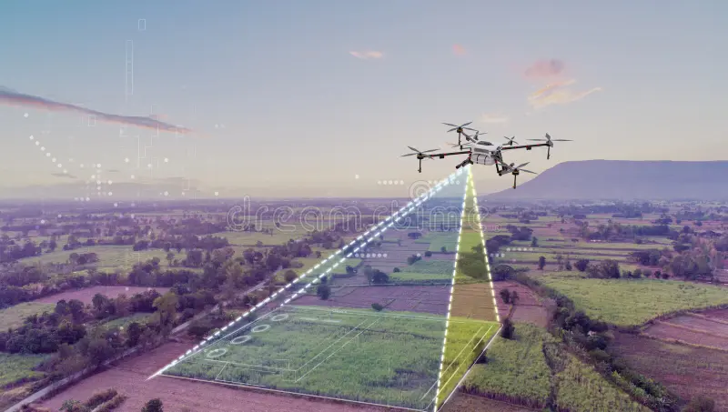
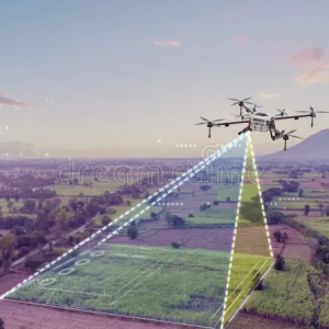
Drone surveying and mapping use unmanned aerial vehicles (UAVs) equipped with high-resolution cameras, LiDAR, and GPS technology to capture detailed aerial data of construction sites, land developments, and infrastructure projects. Drones can quickly survey large areas, providing accurate topographical maps, 3D models, and point clouds that are used for site analysis, design, and monitoring progress. This technology reduces the need for traditional survey methods, which can be time-consuming, costly, and potentially dangerous. Drone surveys improve efficiency, accuracy, and safety while providing real-time data for decision-making. The use of drones in construction also enables monitoring of hard-to-reach or hazardous areas, reducing the need for manual inspections. With the integration of AI and machine learning, drone surveys can offer insights into site conditions, potential risks, and construction delays, making them invaluable for project management and planning.


Sanni –
“Drone Surveying & Mapping has been an absolute game-changer for our construction projects. The detailed aerial maps and 3D models they provide have significantly improved our site planning, excavation accuracy, and property boundary demarcation. Their prompt and professional service has made the entire process seamless. We highly recommend them to any construction professional looking to enhance their project efficiency, safety, and accuracy.”
Semiu –
“Drone Surveying & Mapping is an absolute game-changer for our construction projects. With precise aerial data and real-time monitoring, we can make informed decisions, reduce costly errors, and optimize project timelines. The guides provide clear instructions and practical case studies, empowering us to fully leverage drone technology. The result? Improved accuracy, enhanced efficiency, and significant cost savings. We highly recommend these guides for any construction professional looking to stay at the forefront of industry advancements.”
Khalid –
“Drone Surveying & Mapping has been an invaluable tool for our construction projects. The detailed aerial surveys have provided us with accurate and comprehensive data, allowing us to make informed decisions about site planning, resource allocation, and progress monitoring. The high-quality imagery and 3D models have helped us identify potential risks, optimize operations, and reduce project timelines. We highly recommend this service to any construction company looking to enhance their efficiency and accuracy.”
Fatimatu –
“Drone Surveying & Mapping has revolutionized my construction projects. The precise data and aerial imagery they provided allowed me to make informed decisions, optimize site planning, and streamline construction processes. Their professional team was knowledgeable, responsive, and dedicated to delivering exceptional results. I highly recommend their services to anyone looking to enhance their construction operations with cutting-edge technology.”
Osita –
“Construction guides named “Drone Surveying & Mapping” have been an invaluable asset for our construction projects. The comprehensive guide provides step-by-step instructions for using drones to survey and map sites, ensuring accuracy and efficiency. With easy-to-understand explanations and detailed technical information, this guide has helped us streamline our surveying processes, reduce errors, and improve our project planning. Its clear organization and accessible language make it a must-have resource for anyone in the construction industry.”